A Walk through the gorge of
"Arroyo de la Ventilla"
"Arroyo de la Ventilla"

Prologue:
The village of Arriate is situated on the plains of Ronda at 603 meters above sea level, just 10 minutes drive to the north of the town of Ronda in the Province of Málaga.
The area around Arriate was first habituated during Palaeolithic times. Some caves have been found along the river Guadalcobacin. Much later followed the Romans and thereafter the Moors. In the year 1407 a major battle, which is known as Ambush of Arriate, was fought between Christians troops and the Moslems. In 1630 Arriate gained independence from Ronda. Arriate derives from the Arabic word Arriadh meaning gardens.
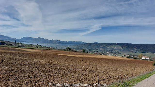
The river to the north and west Guadalcobacin and the stream La Ventilla have shaped the land around Arriate. The village is surrounded by lush agricultural land with wheat fields and olive groves.

The stream "Arroyo de La Ventilla" is especially known for its diversity and beauty, lush in vegetation and animal life if you are prepared to look.
This walk through the gorge of the stream "Garganta del Arroyo de la Ventilla" has much to offer for the whole family and nature lovers alike.
Various information boards are spread throughout the walk which we found very informative.

The Arroyo de la Ventilla Gorge is one of the best preserved forests in the Province of Malaga.
A natural paradise where there is great floristic biodiversity, with more than 650 species.
To this we must add its undoubted geological and landscape attractiveness, this being a wonderful natural spot, one of the most outstanding in Malaga and even in Andalusia.
This gorge acquires special relevance for being one of the last refuges of the vegetation that once covered the Ronda plateau.
Oaks, elms, ash, poplars, holm oaks, wild fruit trees, a great variety of aromatic and medicinal plants, wide and tall ferns, purple loosestrife, lilies and up to twenty species of orchids is a sample of what can be found in this wonderful natural space.
A true natural floristic, faunal and landscape paradise, which it is possible to enjoy while walking along one of the paths found inside and on the margins of the gorge.
Information taken from board.


Directions:
- Drive west of Marbella on the A-7 and in San Pedro de Alcantara turn towards Ronda A-397.
- In Ronda at a large junction take 2nd exit onto A-367.
- After approx. 5,5km turn left onto A-428 towards Arriate.
- In Arriate turn right after Venta El Chozo, and in Calle el Prado you will find a large carpark.
- There you follow the way signs Sendero Arroyo de la Ventilla.
- From San Pedro de Alcantara it takes roughly 1 hour/55km.

Map of the hike

 |
| Click on link: Wikiloc: Arriate, Arroyo de la Ventilla |
- The Hike is approx. 5,3 km, a circular walk through the gorge and up to the other side.
- Our starting point was at the carpark in Calle el Prado. Here you find way signs pointing towards the walkway of "Sendero Arroyo de la Ventilla".
- Afterwards, we walked back to the village via the extra large bench !
- which was an easy walk on a tarmac road.
- Note: Some of the paths might be slippery, especially in the wintertime and after heavy rain.

The actual walkway starts about 800 meters from the carpark.

We follow the path along side olive groves and almond trees.

From mid January to the end of February the almond trees are in full blossom.

Genista, or broom bushes, with their yellow flowers are one of the first signs of spring.
.jpg)
In early spring from February, March on wards, you will find that the countryside in Andalusia becomes very colourful. Wild flowers are in bloom everywhere. You can see fields of lilac, blues and yellows. The thorny shrubs suddenly have fragrant flowers. One of them is the Genista with its yellow small flowers.
 |
| Spanish Iris Lirio Español (Iris xiphium) |
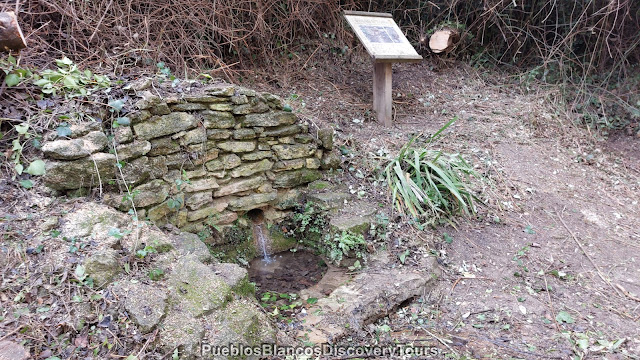
Further on we come across a small fountain.

Information taken from board.
Arriate ground is of carbonate origin that allows the permeability of water from rain, which creates reserves under the surface and springs.
The Fuente de los Cañolillos adopts this name from its source, a spring that collects the waters of the Ronda depression to supply with its flow first the pool located next to the path, to subsequently irrigate the ancestral orchards that then extend to both banks of the Ventilla Gorge.
Ethnographically, this fountain is located next to a path, called the Molino Cantos road, flanked by stone walls that show the know-how of the peasantry. Although it exhausts its flow at certain times of the year (especially in the summer period), it is a water supply of vital importance for the conservation of the vegetal and agricultural landscape of the municipality of Arriate.

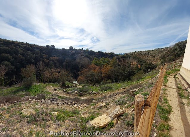
At a clearing on the left side of the pathway we see another information board.

From here you have fantastic views across the gorge.

On the oposite side we notice a very large bench on top of the cliff, it looks interesting.
That is the way we are heading, to have a closer look.

Below, some man made structures are set in the cliff wall.
No idea what they might be!


This fountain only had a trickle of water, due to lack of rain this winter.
The dampness and time, showed up on the information board.
It was barely readable.

Information taken from board
Water emerges from the depths of the earth through an Arabic drain tile, which the fountain has adopted its name "Fuente de la Tejilla". The quality of the water source is appreciated by the inhabitants of Arriate who come here to stock up on water or quench their thirst on their daily walk through the Arroyo de la Ventilla Gorge.
The Arriate City Council has dedicate specially a workshop to preserve the spring and source, because it is of environmental and cultural interest of the municipality.
This well does not dry out in any season of the year, which contributes positively to increasing the flow of the Ventilla stream, especially in the summer season, thereby maintaining the sublime riverside forest that grows in this area, made up of ash trees, elms, poplars and gall oaks.

We walked across the bridge

and follow the narrow trail downwards.

The geological make up of the gorge looks very interesting.

Having reached the bottom of the gorge, we find some picnic tables set between very tall trees.

And another notice board explaining the fauna which can be found in this area.

From here you have varios options of pathways.
First we walk across the bridge and follow the track down stream and up hill!

A pretty view upstream,

and another one down stream.

We come across some ruins which we saw earlier on across the gorge.

The dwelling seem to have been built into the rock.

We wonder who has lived there over times past!

With time, the vegetation is engulfing the manmade structure.

A bit further on we stand in awe and look up at the rock face.

The natural elements have formed this rock through millenniums.


A small path then leads down to the stream.

We then decided to walk back to the bridge by the picnic table

and followed the path up stream.

Over another bridge,

and uphill.


Steadily we climb higher.

A view back, from the other side of the bridge.

Surrounded by lush vegetation, we have the feeling being in a Mediterranean jungle.

We are fascinated by these large trees!

Poplars, Elms, Ash, Holm oaks, all more than 20 meters tall.

It seems that nature is still intact here.


A view across the gorge and over the tree tops.

This view takes you along the gorge and back towards the west.

The panoramic views are incredible from up here.

It is certainly worth it, to have done the steep climb up to here.
Near a white building, an information board explaining about the history of the gorge.

It reads, that the the gorge of Arroyo de la Ventilla is a geological jewel and is one of the most preserved area in the Serrania de Ronda.
For more than 10 million years ago, this area was completely submerged under the sea. As the water subsided it sculpted the slopes of the more then 5 km long canyon, formed caves and turned it into a real geological museo. The sedimentary material is of conglomerate sandstone and calcareous silt with marine fossils.


A view of the building we have just walked around.

There is no shortage of picnic places along this walk.

This cave is still home to certain animals I'm sure.

Up here we find a different vegetation.
The plants which grow here, are used to drier and rockier grounds.
Blooming lavender and rosemary bushes are just one of them.

Spanish irises look small and dainty, be careful not to step on them.

An ideal spot to take in the panorama.

To the east far away, a glimpse of the Sierra de las Nieves, the snowy mountains,
without snow at this moment!

Across the gorge towards south west.

This board had information in English as well.

From now on it was easy going,
We followed a tarmac road which leads back to the village.

It is so nice to see the almond blossoms.

They flower from mid January to the end of February.

A view across an Olive grove.

At last we have found our destination which had intrigued us earlier on!

We didn't want to miss the giant bench "Banco Gigante".

The large bench fits to the scene.
It is out of proportion, like the deep cut into the fertile undulating countryside.

Of cause we had to try it out. The climb up made it well worth the effort.

Like Tom Thumb !!!

What a panorama from up here!


As we strolled along we could heard a loud
EeeAaaWW !!


He expected us to stroke him.

This olive tree looked rather old.

 |
| Genista or Broom |

It certainly was a memorable walk and we hope to be back very soon.

Map of the Hike

